IW:LEARN The exclusive economic zone of Tonga, nearly 700,000 km squared of ocean, is 1000 times larger than the country’s land area. The largest stock of natural wealth for the people of Tonga is derived from coastal and marine ecosystem services reporting a net economic value around USD30 million in GDP in 2013*.
At the 2017 Ocean Conference, Tonga announced its commitment to 30% Marine Protected Area within its jurisdictions and spatially mapping ocean uses and benefits, and threats to biodiversity with a vision of “ecologically sustainable social and economic development of Tonga’s ocean for the benefit of all Tongans”.
The Pacific Community’s GEF-funded Tonga International Waters Ridge to Reef (R2R) Project tested mainstreaming of R2R and climate resilient approaches to sustainably and holistically manage their resources from land to the sea.
Ministry of Lands and Natural Resources Chief Executive Officer Rosamond Bing said:
“The connectivity of ecosystems from land to sea, primarily through water, and the impact of climate change on ecosystem goods and services are fundamental to our approach to resource management. This project enables us to test innovative solutions to integrated and climate resilient approaches to land, water, forest, biodiversity and coastal resource management and prioritize conservation initiatives and the identification of areas to be protected”
Acting Pacific R2R Regional Programme Coordinator Samasoni Sauni said, “The GEF IW R2R project is testing new ways to support evidence-based decision making in the integration of Integrated Water Resource Management and Integrated Coastal Management planning to guide future R2R investments for replication and upscaling.”
In pursuing R2R mainstreaming, Sauni explained that the R2R science-to-policy framework sets out scientific and technical processes that include the:
- Rapid Assessment of Priority Coastal Areas (RAPCA)
- Island Diagnostic Analysis (IDA)
- State of the Coast Report (SoC)
- Strategic Action Framework and Planning (SAF, SAP)
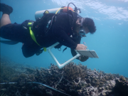
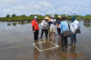
Tonga IW R2R Project Manager Silia Leger explained that the testing of the Rapid Assessment of Priority Coastal Areas (RAPCA) procedure in Tonga in May, will help diagnose the state of the environment at the local demonstration site on the west coast of the main island of Tongatapu.
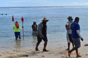
The RAPCA diagnosis will support decision-making for the prioritization and identification of Special Management Areas, including fish Reserves in 6 villages in the Hihifo District, with potential for upscaling.
The RAPCA has also facilitated cross-sectoral planning and joint implementation of data collection activities involving the Ministries of Fisheries, Environment, Lands and Natural Resources and the Vavau Environmental Protection Association (VEPA),” she continued.
RAPCA Principal Investigator and VEPA Manager Karen Stone said: “Coastal habitats face a myriad of threats to biodiversity and ecosystem health including land degradation, pollution, unsustainable practices, overfishing and natural disasters that are increasing with threat and impact due to anthropogenic caused climate change.”
The RAPCA surveys include all coastal habitats and recording and identifying unique and threatened biodiversity, invasive species and establishing recommendations that support the protection and management of ecosystems.
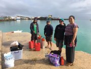
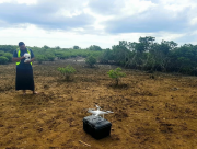
Other components of RAPCA include socio-economic household surveys and water quality analysis conducted by the Ministry of Lands and Natural Resources.
Results of the RAPCA surveys will be published and made available through the Pacific R2R Science Portal. The RAPCA procedure was also trialled in Vanuatu in 2019, with plans to conduct it in the Cook Islands later this year.
Tonga had three GEF-funded R2R projects, 2 of which are still operational, with the Ministry of Environment (closed in 2018), Ministry of Lands and Natural Resources, and the Ministry of Agriculture and Forestry.
Original publication: https://news.iwlearn.net/innovation-for-a-sustainable-future-for-the-kingdom-of-tonga